
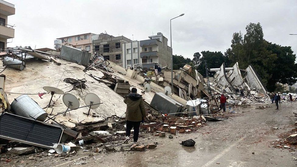
The 7.8 magnitude earthquake that occurred in Turkey on Monday has shifted the land of Turkey by 10 feet i.e. about 3 meters. This claim has been made by Italian seismologist Dr. Carlo Dogliani. Earlier in 2011, reports of Japan and India slipping in 2022 also came out.
In TPS Explainer, we will know how Turkey shifted 10 feet due to the earthquake, what is the cost of land sliding and which countries are more prone to land sliding.
How did Turkey move due to the earthquake?
To understand the reason for Turkey’s land sliding, we have to understand its location.
Actually, the world is situated on large tectonic plates. Beneath these plates is liquid lava. These plates keep on floating and collide with each other many times.
Most of Turkey lies on the Anatolian tectonic plate. This plate is stuck between the Eurasian, African and Arabian plates. When the African and Arabian plates shift, Turkey gets sandwiched. This releases energy from inside the earth and causes earthquakes. Monday’s earthquake in Turkey occurred on the North Anatolian Fault Line.
According to Italy’s seismologist Dr. Carlo Doglioni, the Anatolian tectonic plates and the Arabian plates have shifted 225 kilometers away from each other. Due to this, Turkey has shifted 10 feet from its geographical place.
Doglioni explains that due to this change in tectonic plates, Turkey has sunk 5 to 6 meters i.e. about 20 feet more than Syria. Although he made it clear that this is information from the initial data. In the coming days, accurate information will be available from satellite images.
Dr. Bob Holdsworth, Professor of Structural Geology at Durham University, said that it is natural for the plate to shift after such a powerful earthquake. He explained that there is a direct correlation between the intensity of earthquakes and the movement of tectonic plates. There is nothing in it that is awkward.
He told that tectonic plates can move up to one meter when an earthquake of 6.5 to 6.9 magnitude occurs.
Turkey’s price of sliding up to 10 feet
Pro. According to Holdsworth, if an earthquake of such high intensity causes a horizontal shift of 3 to 6 meters in the tectonic plates surrounding Turkey, then it is natural. The reason is that Turkey is in a zone of strong earthquakes.
Such horizontal movement of tectonic plates can break roads, buildings, borings, water, or petrol pipelines. Along with this, the direction of the rivers can also change.
Dr. Joanna Farey Walker, Professor of Earthquake Geology and Disaster Risk Reduction at University College London, said that both were strike-slip earthquakes. He said that due to strike-slip faults, there is a possibility of an earthquake of magnitude 7 or 8. As seen in Turkey.
On March 11, 2011, the most powerful japan earthquake ever recorded occurred with a magnitude of 9.1. This powerful earthquake not only killed people but also shifted the earth’s axis by 4 to 10 inches. Along with this, the speed of the daily rotation of the earth also increased.
At that time, USGS seismologist Paul Earle said that this earthquake has shifted Japan’s largest island Honshu about 8 feet east of its place. During this, there were more than 160 earthquakes in the first 24 hours. Of these, 141 had a magnitude of 5 or more. This earthquake and tsunami in Japan killed more than 15 thousand people.
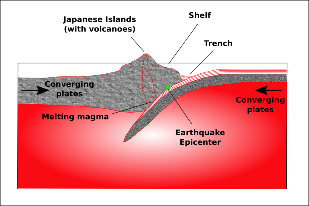
Japan is in the most sensitive area to earthquakes. It falls in the Pacific Ring of Fire region. The Ring of Fire is an area where there are several continental as well as oceanic tectonic plates. When these plates collide with each other, earthquakes occur, tsunamis arise and volcanoes erupt.
The effect of this ring of fire can be seen from New Zealand to Japan, Alaska, and North and South America. 90% of the world’s earthquakes occur in this Ring of Fire region. This area is spread over 40 thousand kilometers. 75% of the active volcanoes in the world are in this region. 15 countries are in the jurisdiction of this Ring of Fire.
India is also moving toward Europe
In the year 2022, geologists from Australia prepared a new map of all the tectonic plates on Earth. It was told that the microplate between the Indian Plate and the Australian Plate has been included in the map. It was also said that India is moving towards Europe.
Due to this, it is expected that in the coming days, due to the collision of these two plates, there may be a severe earthquake in the northern parts including the Himalayas. Dr. Derrick Hastrock, lecturer in the Department of Earth Sciences at the University of Adelaide, Australia, and his colleagues have prepared this map together.
Dr. Derrick has said that our map tells the complete story of 90% of the earthquakes and 80% of the volcanic eruptions on the earth in the last 2 million years. At the same time, the current model gives information about only 65% of earthquakes. With the help of this map, people can calculate natural calamities.
On 26 December 2004, the Indira Point of the Andaman-Nicobar Islands was submerged due to the earthquake and subsequent tsunami in Indonesia. This island is located at a distance of 138 km from Sumatra.
There is only one lighthouse here which was inaugurated on 30 April 1972. It is located in the extreme south of India and it is also called the last point of India.
It is named after the former Prime Minister of India, Indira Gandhi. The lighthouse at Indira Point serves as a beacon for ships going to Malaysia and Malacca via India.
The island was formed in Bhuj due to an earthquake 204 years ago.
In India, 204 years ago i.e. in the year 1819, an island was formed due to an earthquake in Bhuj, Gujarat. This is known as Allah Bandh. According to scientists, it is possible to happen when an earthquake of more than 7.8 intensity occurs on the Richter scale.
The reason for this can be attributed to the rift between the plates inside the ground. Experts say that these plates move continuously. Sometimes there is a rift between them.
In such a situation, if an earthquake of more than 7.5 magnitudes and more depth occurs inside the sea, then these plates climb on top of each other many times. If the plates take a height of even 6-7 meters, then it becomes an island-like situation.
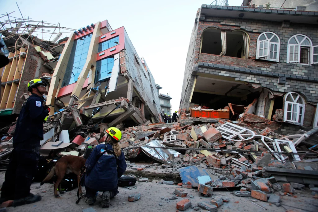
The devastating Nepal earthquake in April 2015 not only claimed hundreds of lives, but also disturbed the Himalayan country’s geography.
Tectonic expert James Jackson of the University of Cambridge told that after the earthquake, the ground beneath Kathmandu shifted three meters i.e. about 10 feet to the south.
However, there are no signs of any change in the geography of Everest, the world’s largest mountain peak. This earthquake in Nepal was as powerful as 20 big nuclear bombs.
A part of India slipped up to 10 feet in Nepal
Sandy Stacey, a scientist at the University of Adelaide, claimed that due to the pressure caused by the Himalayas, the northward-moving Indian tectonic plates, called the Eurasian plates, have shifted 10 degrees to the northeast. Because of this, a part of India slipped below Nepal by about one to ten feet in a short time during the earthquake. In this entire geographical process, about one to two thousand square miles of area of the Himalayas has shifted.
According to Colin Stark, associate research professor at Lemont-Doherty Earth Observatory, Columbia University, USA, the upper surface rocks (which are limestone rocks) in Bihar, bordering Nepal, are moving northwards in a few seconds and towards Nepal. Got down.
Due to this friction in the Indian plate, it has affected the Janakpur zone from Bharatpur to Hitoda in Nepal. The Indian land (East-West Champaran) adjacent to this area has gone under the surface of Nepal.
It has become clear that the entire Indian subcontinent is going under the fault (rift) of Nepal and Tibet at a very slow pace. The speed of going under the surface of Nepal and Tibet of the Indian subcontinent is 1.8 inches every year.
In 2013, an earthquake formed a 300 feet long island in the sea of Gwadar.
On 25 September 2013, 7.8 magnitude earthquakes struck Balochistan, Pakistan, creating an island in the sea in the coastal city of Gwadar.
This egg-shaped island was 250 to 300 feet long and about 60-70 feet above the surface of the water.
Its surface is rough and most of the area was covered with mud. There was also sand in some areas. It also had solid rock in one area.